
Publications
فلڈ بلیٹن اور ایڈوائزری
Flood Bulletins & Advisories issued by the Flood Forecasting Division
Official copy


RIVERS AT A GLANCE
| INDUS Below Low | KABUL Below Low | JHELUM Below Low | CHENAB Below Low | RAVI Below Low | SUTLEJ Below Low |
FLOOD SEVERITY SCALE
| Below Low | Low | Medium | High | Very High | Exceptionally High |
Note: FLOOD SEASON 2026 HAS BEEN CONCLUDED,
NEXT FORECAST BULLETIN WILL BE ISSUED ON 15th June 2027.
RAINFALL FORECAST — NEXT 24 & 48 HOURS
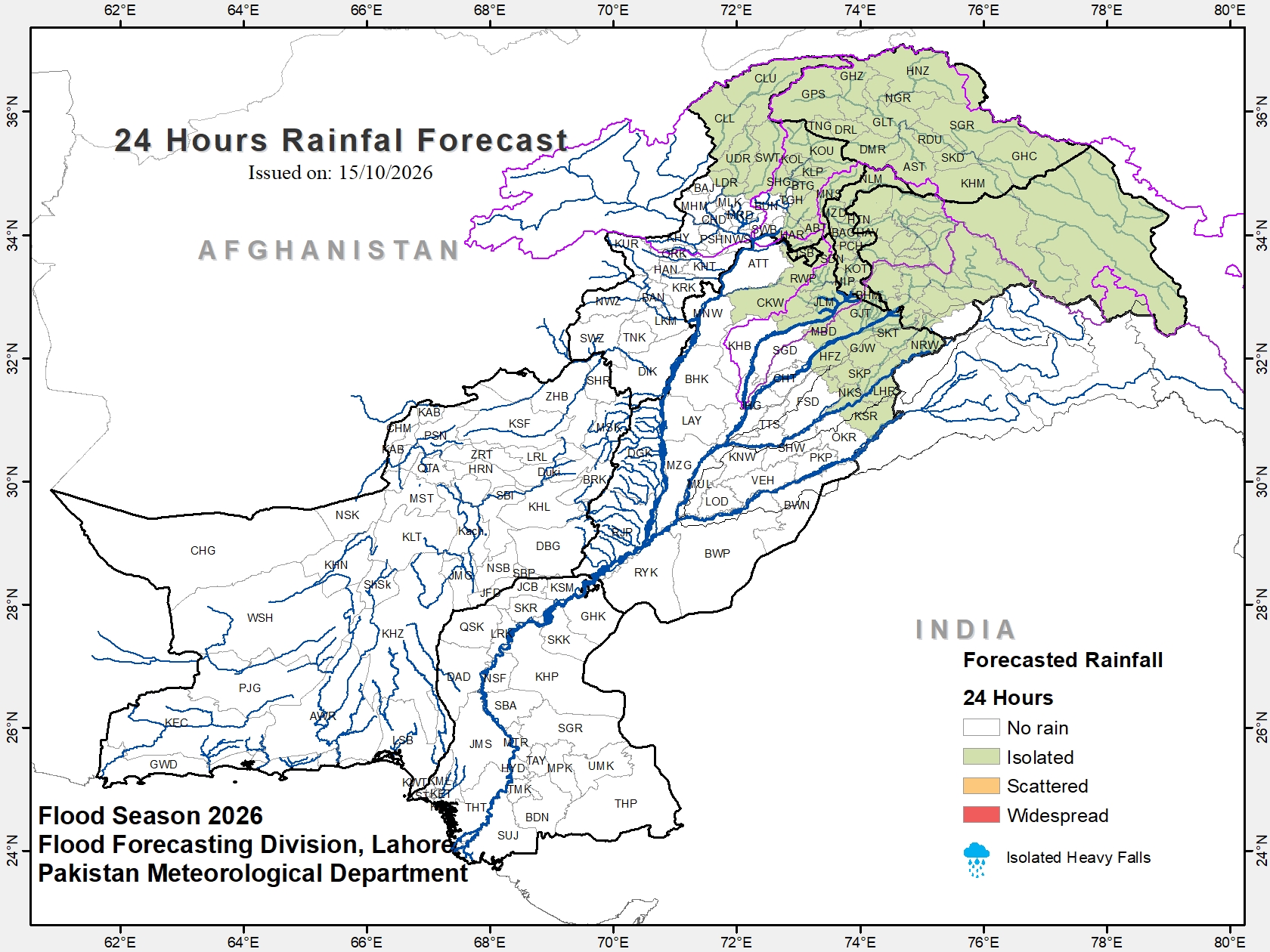 Rainfall forecast — next 24 hours | 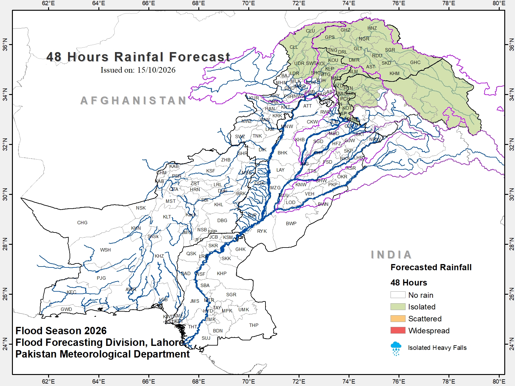 Rainfall outlook — next 48 hours |
RIVERS SITUATION AND QUALITATIVE FLOOD FORECAST
I. METEOROLOGICAL FEATURES
- Yesterday's trough of westerly wave over the northern parts of the country still persists.
II. METEOROLOGICAL OUTLOOK
Isolated rain-wind/thunderstorm is expected over the upper catchments of river Indus, Jhelum and Chenab, Islamabad, Kashmir, Gilgit Baltistan, Upper Khyber Pakhtunkhwa and north Punjab.
III. HYDROLOGICAL SITUATION at 0600 PST
- All major rivers are flowing in their normal flows at all gauging stations.
IV. HYDROLOGICAL OUTLOOK
- Flows in all major rivers are expected to remain within the normal flow range at their respective rim stations.
V. WEATHER FORECAST FOR 24-HOUR
Isolated rain-wind/thunderstorm is expected over the upper catchments of river Indus, Jhelum and Chenab, Islamabad, Kashmir, Gilgit Baltistan,
Khyber Pakhtunkhwa: Abbottabad, Batagram, Chitral, Haripur, Kohistan Lower, Kohistan, Mansehra, Shangla, Swat and Dir.
Punjab: Chakwal, Gujranwala, Gujrat, Hafizabad, Jhelum, Kasur, Lahore, Mandi Bahauddin, Narowal, Nankana Sahib, Rawalpindi, Sheikhupura and Sialkot.
VI. WEATHER OUTLOOK FOR NEXT 48-HOURS
Mainly dry weather is expected over the most parts of the country, however, Isolated rain-wind/thunderstorm is expected over the upper catchments of river Indus and Jhelum, Kashmir, Gilgit Baltistan,
Khyber Pakhtunkhwa: Batagram, Chitral, Kohistan, Mansehra, Shangla, Swat and Dir.
WEEKLY SIGNIFICANT OUTLOOK
(16th October, 2026 to 21st October, 2026)
I. RAINFALL OUTLOOK
Mainly dry weather is expected over the most parts of the country.
II. FLOOD OUTLOOK
Flows are expected to remain normal at all rim stations of all the major rivers during the period.
3. WEATHER/RAINFALL FORECAST FOR NEXT 24-HRS
| RIVERS | Upper Catchments (Above Rim Stations) | Lower Catchments (Below Rim Stations) | RESERVOIRS LEVEL (FEET) at (0600 PST) TARBELA
1380.00 dead → 1550.00 max cons.
0.960 dead + 3.875 / 6.511 MAF live MANGLA
1040.00 dead → 1242.00 max cons.
1.000 dead + 4.169 / 7.387 MAF live | ||||||||||||||||||||||||||
| INDUS | Isolated thunderstorm/rain | Isolated thunderstorm/rain | |||||||||||||||||||||||||||
| JHELUM | Isolated thunderstorm/rain | Isolated thunderstorm/rain | |||||||||||||||||||||||||||
| CHENAB | Isolated thunderstorm/rain | Isolated thunderstorm/rain | |||||||||||||||||||||||||||
| RAVI | Mainly dry | Isolated thunderstorm/rain | |||||||||||||||||||||||||||
| SUTLEJ | Mainly dry | Mainly dry | |||||||||||||||||||||||||||
4. QUANTITATIVE FLOOD FORECAST OF GAUGING STATIONS (IN THOUSANDS OF CUSECS)
| RIVERS | Stations | Actual Observations at 0600 PST | Quantitative Forecast for Next 24-hrs (Inflow) | Qualitative Forecasted Flood Level (Inflow) | Max Flood Peaks (In Thousands of Cusecs) | |||
|---|---|---|---|---|---|---|---|---|
| Inflow | Outflow | Historical | Flood Season 2026 | |||||
| INDUS | Tarbela | 44.0 | 55.2 | 40 - 45 | Below Low | 832.0 | EH (2010) | 343.0 |
| INDUS | Kalabagh | 50.6 | 44.7 | No. sig. change | Below Low | 950.0 | EH (1942) | 464.1 |
| INDUS | Chashma | 58.4 | 51.2 | No. sig. change | Below Low | 1038.9 | EH (2010) | 378.6 |
| INDUS | Taunsa | 70.2 | 54.4 | No. sig. change | Below Low | 960.0 | VH (2010) | 386.3 |
| INDUS | Guddu | 56.5 | 49.1 | No. sig. change | Below Low | 1199.7 | EH (1976) | 426.9 |
| INDUS | Sukkur | 44.5 | 12.0 | No. sig. change | Below Low | 1166.6 | EH (1986) | 369.5 |
| INDUS | Kotri | 17.9 | 0.3 | No. sig. change | Below Low | 980.3 | EH (1956) | 184.1 |
| KABUL | Nowshera | 17.1 | 17.1 | 15 - 25 | Below Low | 391.3 | EH (1990) | 78.5 |
| JHELUM | Mangla | 7.0 | 16.0 | 5 - 10 | Below Low | 1090.0 | EH (1992) | 137.0 |
| JHELUM | Rasul | 19.4 | 0.0 | No. sig. change | Below Low | 952.2 | EH (1992) | 63.7 |
| CHENAB | Marala | 12.9 | 4.0 | 10 - 20 | Below Low | 1100.0 | EH (1957) | 275.6 |
| CHENAB | Khanki | 9.5 | 3.7 | No. sig. change | Below Low | 1086.4 | EH (1959) | 261.5 |
| CHENAB | Qadirabad | 19.5 | 0.0 | No. sig. change | Below Low | 1078.0 | EH (2025) | 267.2 |
| CHENAB | Trimmu | 16.0 | 2.2 | No sig. change | Below Low | 944.3 | EH (1928) | 193.8 |
| CHENAB | Punjnad | 8.4 | 0.0 | No sig. change | Below Low | 802.5 | EH (1973) | 146.6 |
| RAVI | Jassar | 1.2 | 1.2 | No. sig. change | Below Low | 680.0 | EH (1955) | 36.2 |
| RAVI | Shahdara | 1.4 | 1.4 | No sig. change | Below Low | 576.0 | EH (1988) | 33.6 |
| RAVI | Balloki | 24.3 | 6.3 | No. sig. change | Below Low | 389.8 | EH (1988) | 87.7 |
| RAVI | Sidhnai | 12.0 | 0.0 | No sig. change | Below Low | 330.2 | EH (1988) | 61.7 |
| SUTLEJ | G.S. Wala | 0.1 | 0.1 | No. sig. change | Below Low | 837.0 | ** (1955) | 8.3 |
| SUTLEJ | Sulemanki | 17.0 | 9.1 | No sig. change | Below Low | 598.9 | EH (1955) | 27.2 |
| SUTLEJ | Islam | 9.0 | 7.3 | No sig. change | Below Low | 492.6 | EH (1955) | 10.7 |
Spatial: Isolated=20 to 30% of area | Scattered=31 to 50% of area | Fairly Widespread=51 to 75% of area | Widespread=76 to 100% of area, R= Rising, F=Falling
Intensity (mm/24 hours): Light ≤ 10, Moderate =10.1 – 30, Heavy=30.1 – 70, Very Heavy=70.1 - 150, Extremely Heavy > 150
Note: Concerned Departments may contact FFD, Lahore for rectification up-dation (if any)
5. HOW CLOSE IS EACH RIVER TO ITS LIMIT?
Sidhnai is the closest to flooding at 12.0 — 18.0 below its low flood level (30.0). Each bar is one station’s own flood levels across its maximum capacity; the solid run is the flow so far, the pale run is the room still left.
| Station |
| Now | Max cap. | |||||||||||||
| Tarbela |
| 44.0 | 1500 | |||||||||||||
| Kalabagh |
| 50.6 | 950 | |||||||||||||
| Chashma |
| 58.4 | 950 | |||||||||||||
| Taunsa |
| 70.2 | 1000 | |||||||||||||
| Guddu |
| 56.5 | 1200 | |||||||||||||
| Sukkur |
| 44.5 | 900 | |||||||||||||
| Kotri |
| 17.9 | 875 | |||||||||||||
| Mangla |
| 7.0 | 1060 | |||||||||||||
| Rasul |
| 19.4 | 850 | |||||||||||||
| Marala |
| 12.9 | 1100 | |||||||||||||
| Khanki |
| 9.5 | 1100 | |||||||||||||
| Qadirabad |
| 19.5 | 900 | |||||||||||||
| Trimmu |
| 16.0 | 875 | |||||||||||||
| Punjnad |
| 8.4 | 865 | |||||||||||||
| Jassar |
| 1.2 | 275 | |||||||||||||
| Shahdara |
| 1.4 | 250 | |||||||||||||
| Balloki |
| 24.3 | 380 | |||||||||||||
| Sidhnai |
| 12.0 | 150 | |||||||||||||
| Sulemanki |
| 17.0 | 325 | |||||||||||||
| Islam |
| 9.0 | 300 |
All figures in thousands of cusecs. Full bar = maximum (design) capacity. Solid colour is the flow reached so far and the pale wash beside it is the room still left; the dark line between them is the current reading, printed beneath it. Thin white lines are that station’s flood levels with their thresholds beneath, so the same colour can begin at a different point on every bar. Each band is named inside itself — initialled (BL, L, M, H, VH, EH) where the band is too narrow for the words, and left blank where it is too narrow for those. Stations without a design capacity are not shown.
6. RAINFALL RECORDED — LAST 24-HRS (UPTO 0800 PST)
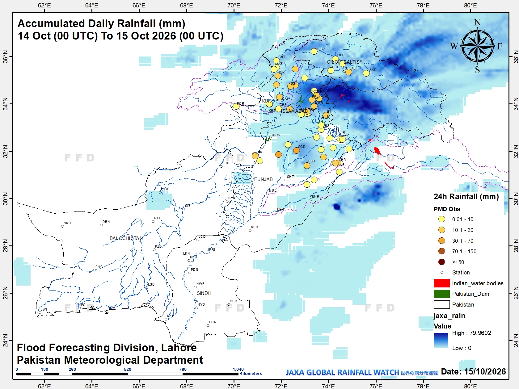 Rainfall recorded — last 24 hours (upto 0800 PST) |
7. RIVERS CATCHMENTS RAINFALL RECORDED (MM) DURING LAST 24-HRS (UPTO 0800 PST)
Indus: Japan Bridge=73, Phulra=33, Kalam=29, Malam Jabba=24, D.I.Khan( City=23, Aairport=12), Khawagoobo Bridge, Shishi Darosh & Besham=20(each), Shinkiari & Murree=19(each), Lower Dir & Saidu Sharif=17(each), Daggar=15, Warsak Dam, Bosak Bridge, Astore & Oghi=14(each), Kakul & Tarbela=13(each), Chowni Bridge Chitral=12, Attock=11, Takht Bai, Arandu Nullah & Gilgit=10, Kabul,Mardan, Dir, Pattan & Gupis=09(each), Mirkhani=08, Risalpur=07, Peshawar (City=07, Airport=05, Bacha Khan Airport=01), Cherat=06, Drosh & Darashoot=05(each), Kohat Airbase & Chitral=04, Kamra Airbase, Phularwan, Chilas & Ghariala=03(each), Parachinar, Bhakkar, Tanda Dam & Bunji=02(each), Landi Kota &, Skardu=01, Dratian=Trace. |
Jhelum: Jamali Balochan=88, Sargodha (City=32, Airbase=23), Garhi Dopatta=30, Palandri=25, Sharda=18, Kotli=15, Rohtas=11, Muzaffarabad (Airport=10, City=09), Islampura=08, Jhelum=06, ManglamBalakot & Baba Shah Jalal=05(each), Joharabad, Domel=03(each), Hattian Bala=02. |
Chenab: Noorpur Thal=48, Hafizabad & Daulatnagar=10(each), Sialkot [Airport & Cantt=06(each)], Barnala=03, Gujranwala=02, Gujrat=01, Aik Nullah (Ura)=Trace. |
Ravi: Lahore = Shadi Pura=28, Air Port & Chowk Nakhuda=27(each), Upper Mall=25, Lakshmi Chowk & Tajbagh Disposal=22(each), Tajpura =21, Gulshan-e-Ravi,Farrukhabad & Lahore Jail Road=19(each)., Samanabad =18, Mannawan & Islam Pura Bazar=16(each), Shahdara & Siddique Pura Center=15(each), Iqbal Town & Shadbagh Disposal=12(each), Pani Wala Talab, Gulberg & Johar Town =10(each), Thokar Niaz Baig & Nishter Town Disposal=09(each), Kahna =08, Jubilee Town=07, Mughalpura =05, Nishter Town 04, Garden Town Ali Block=03, Saggian=02, Hydya Defense Road=Trace(each),Sheikhupura=16, Faisalabad=15, Okara=10, Kotnaina=02, Narowal=Trace. |
Sutlej: Kasur=Trace. |
Saqib Hussain
Senior Meteorologist
for Chief Meteorologist
FFD Lahore
Distribution:
President Secretariat, Islamabad
PM House, Islamabad
Governor (All Provinces)
Chairman NDMA, Islamabad
Chief Minister (All Provinces)
Secretary, Ministry of Defence, Islamabad
Secretary, Ministry for Water Resources, Islamabad
Secretary, Ministry of Information, Islamabad
Secretary, Climate Change, Islamabad
The Secretary General, Red Crescent, Islamabad
Secretary, Irrigation Department (All Provinces)
Chairman NHA, Islamabad
Chief Secretary (All Provinces)
DG Pak Met Services, Islamabad
DG Engineers, Engineering Directorate GHQ, Rawalpindi
PDMAs (DGs – All Provinces/Gilgit Baltistan)
SDMA Azad Jammu & Kashmir
Chairman, Federal Flood Commission, Islamabad
Chairman, Indus River System Authority, Islamabad
Chairman, PCRWR, Islamabad
Pakistan Commissioner for Indus Waters (PCIW), Islamabad
Chief Engineer, Mangla/Tarbela/Chashma
Chief Engineer, Irrigation (All Provinces)
Chief Engineer (All Barrages)
Chief Engineer, C.D.O., Muzaffarabad
All Other Concerned
This page is the authoritative copy of this bulletin. If the code printed on your copy does not match the one below, that copy is not the current version — it has either been altered, or superseded by a correction. Compare it against the bulletin shown on this page.
6fd9 0d96 3fe2 347c d4c8 7e64 c2c3 75a9
sha256sum
10a0 8cb1 d117 6ace 7901 9abe 927e 93c8 4292 1776 839a 09e2 5daa 02ef 3ba4 6158